Pillars of Brinsley Samaroos achievements
Monday, July 17, 2023
Attributes of the Incoming President
Friday, December 30, 2022
Venezuela Clinging at Legal Straws to Delay the ICJ Arbitration with Guyana
Monday, November 21, 2022
The British Re-Conquest of India
Friday, November 11, 2022
Tribute to Horace Hollister Broomes
Wednesday, September 7, 2022
Keep Adversarial Domestic Politics at Home
Monday, August 22, 2022
SEA Results Must be Published
Sunday, July 3, 2022
The Indentures Did Not Affect the Wages of the "Apprentices"
Tuesday, June 14, 2022
Indian Arrival Day Celebrations Not Historically Driven
Tuesday, June 7, 2022
India's Strange UN Abstention Vote on Condemning Russian Aggression
Wednesday, March 16, 2022
|
Tobago's Secession Will Not Reduce Our Marine Resources
By Stephen Kangal
July 14, 2008
During his statement made in the House on Monday 7 July on the Municipal Corporations Bill to extend the tenure of Local Government bodies for the third time, PM Manning issued a false, alarmist and totally misleading allegation to the effect that were Tobago to secede the quantum of our current marine resources now under our jurisdiction and control within our maritime areas would be diminished with catastrophic results.
On this issue both Senators and MP's appear to be at sea because they accepted it without question as they accepted the erroneous statement made by former AG John Jeremie on the judgment on 11 April 2006.
This is part of a larger issue that I addressed during a lecture presentation made to the Tobago Forum on Constitutional Consensus at their invitation and held on Thursday 3 July at the Works Lecture Theatre in Scarborough.
The lecture was entitled "The Strategic Role of the Tobago Factor in the Evolutionary Development of the Public and Private Maritime Order of Trinidad and Tobago- Some Recent Fishing and Delimitation Issues"
Were Tobago to secede (God forbid) the only major victim from a Law of the Sea perspective will be our archipelagic status that we declared on 31 October 1988 via Legal Notice No.206 entitled The Archipelagic Baselines of Trinidad and Tobago Order, 1988 (See Chart attached).
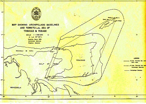 Map showing Archipelagic Baselines and Territorial Sea of Trinidad and Tobago
There will be a consequent reduction in the size of our internal (archipelagic) waters but not in the existing areal extent of our maritime jurisdiction as determined by our boundaries with Barbados and Venezuela. All our current marine resources (living and non-living) will be assimilated either within the jurisdiction of the new state of Tobago or of Trinidad. There will be no substantial reduction in the extent of the maritime areas over which we now exercise control at present.
The existing maritime boundaries with Barbados and Venezuela will not be altered because the straight (archipelagic) baselines were not used to determine the 1990 boundaries with Venezuela either in the Gulf of Paria or in the Atlantic.
As for the boundary determined by the Tribunal with Barbados the entire length of the line is derived from equidistance measurements taken from Tobago and none from Trinidad. In fact the successor boundary agreement will be negotiated exclusively between the new state Tobago and Barbados with Trinidad having no locus standi in the matter. The extent of Tobago's maritime jurisdiction will be considerably enhanced. (See Chart with Lines drawn from Tobago)
Only the relatively relevant longer coastal façade that is facing the area to be delimited and measured from Little Tobago to Point Galeota (70 nautical miles) caused The Tribunal to shift the equidistance measured boundary eastwards from points 10 to 11 (area of 300 square nautical miles) terminating at the intersection of the TT/Venezuela boundary and the 200 nautical miles arc drawn from the turning point on Little Tobago.
Both emerging new states will still remain disadvantageously zone-locked and shelf-locked. Soon Barbados will have already crystallized its outer continental shelf claim before the UN Commission on the Limits of the Continental Shelf and will be exercising sovereign rights over the resources of the seabed that is in fact T&T's natural prolongation and not Barbados'.
It is to noted that Barbados has been awarded EEZ rights by the distance criterion of 200 miles over marine areas that are beyond doubt the geo-morphological and geological natural prolongation of both Trinidad and Tobago and Venezuela. It is this marine platform that Barbados will use to justify its claim extending to the edge of the continental margin (350 miles) that marks the limit between national jurisdiction (Barbados) and international jurisdiction (The International Seabed Authority). (See Chart 7.5 attached)
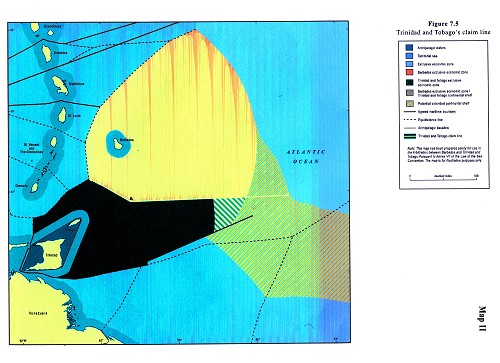 Chart showing Trinidad and Tobago's claim line
|
|
|