|
The 1990 Treaty Established an Equitable Boundary
Posted: Wednesday, May 12, 2004
By Stephen Kangal
The cardinal rule of maritime boundary delimitation is the obligation that devolves upon the states concerned to conduct negotiations with a view to achieving an agreement on the establishment an equitable maritime boundary. Under the now defunct 1958 Geneva Convention on the Continental Shelf states, that could not hammer out a mutually acceptable agreement were under an obligation, in the absence of special or relevant circumstances peculiar to, inter alia, the geography of the area to be delimited, to use the median or equidistance method to fix their maritime boundaries. However in the 1982 Convention on the Law of the Sea, Articles 74 and 83 make no reference to these methods and place emphasis on the achievement of an equitable delimitation by agreement or third party adjudication.
This was therefore the objective of the T&T /Venezuela joint negotiators beginning in 1973 and terminating in April 1990. The negotiators first had to identify the respective maritime zones to be delimited e.g. the territorial sea (TS), the Exclusive Economic Zones (EEZ), continental shelf (CS) as well as the location where T&T and Venezuela were in an opposite and/or adjacent locations vis-a -vis each other. It was agreed that the EEZ and the TS were based on distance criteria of 12 and 200 nautical miles respectively and not on geological/geomorphologic considerations that characterised the CS located beyond 200 miles.
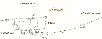
Accordingly Points 1 to 8 of the agreed boundary as shown on the attached chart were established using the equidistance (adjacent)/ median methods (opposite locations). The negotiators used the AB boundary of the old 1942 Gulf of Paria Treaty to fix points 8 and 9 (TS). This 1942 Treaty formerly, that is from February 1942 to 23 July 1991(date of ratification) marked the bilateral limits of the submarine areas lying between T& T and Venezuela when the countries observed a 3-mile territorial sea that is now replaced by the 12-mile TS.
In fact the median line method was used to fix the boundary between points 9 and 15 on the chart. Had this method been used to fix the boundary beyond 15 it would violated a relevant or equitable circumstance, i.e the rights acquired by T&T by reason of the South - Coast oil concessions awarded and exploited by companies such Amoco, Trintoc atc. This right to these concessions were crystallised and justified on the basis of the exploitability criterion of the above-mentioned 1958 Convention. Accordingly the points 15 to 19 are in fact the southern extremities of the T&T oil and gas offshore concessions and not the equidistance line. A marine area of 44 square miles lay beyond the hypothetical equidistance line.
Points 19 to 20 were derived by the resumption of the use of the equidistance method because there were no relevant circumstances to be factored in the negotiations to deflect this line northwards or southwards.
Having regard to the concavity of the coastal façade resulting from the relative geographical locations of T&T, Venezuela and Guyana, the negotiators agreed that further eastwards use of the equidistance method beyond point 20 would have resulted in a shut-in or zone and shelf-locked position for Venezuela at 117 miles measured from its coastal façade at Punta Playa. That would have produced inequity and prevented Venezuela from exercising high seas egress to the Atlantic Ocean.
Consequently the negotiators drew a perpendicular of 6 miles from point 20 along the meridian to point 21 and used an azimuth of 70 degrees to end at point 22.This point 22 is located beyond 200 miles from the coasts of both T&T and Venezuela and marks the limits of the continental margin based on the natural prolongation principle of Article 76 of the 1982 Convention on the Law of The Sea. The precise location of point 22 will be fixed by consulting geomorphologic data on the topography of the submarine areas (continental shelf) together with discussions to be conduced with the Jamaica-based International Seabed Authority (ISA) as well as the UN Commission on the Limits of the Continental Shelf to finally establish the limits between national and international jurisdiction in this area.
The attached chart illustrates the 22 points of the 1990 Treaty Between the Republic of T&T and the Republic of Venezuela on the Delimitation of Marine and Submarine Areas that was ratified and entered into force on 23 July 1991 in POS.
 Send page by E-Mail Send page by E-Mail
|
|