|
Treaty Not Prejudicial to Guyana
Posted: Monday, March 1, 2004
by Stephen Kangal, Caroni
Having stated unambiguously in my last Trinicenter submission that contrary to the allegations of PM Arthur, the TT/Venezuela Maritime Boundary did not encroach on or allocate either to T&T or to Venezuela potential or actual Guyanese maritime territory /jurisdiction/rights I am grateful for the facility to put the case, pro bono for the defence.
My submission is derived from consulting primary sources of documentation as well as from actual participation in the negotiations as a Law of the Sea adviser/ Secretary to the TT delegation. I have studied/researched and written on this subject for 30 years.
PM's Arthur's allegations (Newsday Feb.17, p.4) and those of the PNM in July 1991 (Messrs Rowley, Manning, Imbert, the late Morris Marshall, John Scott etc) were driven by a false and misleading assumption that the median/equidistance method of maritime boundary delimitation was obligatory under international law of the sea. The current Executive Director of Newsday will remember the furore generated while conducting her duties at her previous journalistic incarnation in 1991 at another place.
I understand that Barbados unwittingly and per incuriam, has been insisting on the obligatory nature of this method in its current delimitation negotiations with T&T. In the face of T&T's internationally admissible and recognised position that it is not, Barbados has prematurely, unilaterally and impulsively, but quite improperly taken T&T before the jurisdiction of an Arbitral Tribunal to be constituted in accordance with Annex VII of the Convention jointly by the UN Secretary General/ International Tribunal For the Law of the Sea (ITLOS) in Hamburg, Germany. An assessment of the relative frivolousness and vexatious character of the Barbados case will be my next Newsday article.
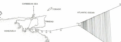
However even if this method were to be applied, the 1990 boundary, from a T&T perspective, is located 5 miles westward of the tri-junction point (117 miles from each land point) where the notional equidistance boundaries of Guyana, Venezuela and T&T meet and converge. The said boundary then veers 6 miles due north to constitute point 21 and follows an azimuth of 70 degrees provisionally terminating at the last point 22 that marks the edge of continental margins of both Venezuela and T&T. This point is located 221 miles from Kitridge Point in Barbados.
Point 20 of the 1990 TT/Venezuela Boundary is unequivocally located on the notional equidistance line drawn between T&T and Venezuela using Point Galeota (T&T) and Punta Playa on the Venezuelan border with Guyana. That is T&T rejected the Venezuelan promulgated Leoni Line across the mouth of the Orinoco that terminated at Point Waini in Guyana. Guyana is no where in the bilateral maritime delimitation equation at Point 20 as an opposite state as far as T&T is concerned.
Accordingly the marine areas (living and non-living resources of the sea, seabed and subsoil) located east of the aforementioned point 20 and southwards of the agreed boundary (points 21 to 22) are subject to the concurrent or overlapping maritime jurisdictions and control of both Guyana and Venezuela (See shaded areas of chart affixed). T&T is not in the picture beyond point 20. The legal status of these areas must be determined or apportioned by agreement arising from bilateral negotiations or third party adjudication having taken into account the delimitation criteria prescribed in Article 74 of the Law of the Sea Convention.
Beyond 117 miles (5 miles east of Point 20) along the notional equidistance boundary, Venezuela would have become zone-locked and prevented from enjoying a high seas egress to the Atlantic (salida al Atlantico) for navigation and the legitimate exercise of its EEZ/ continental shelf rights beyond 200 miles. This was an equitable consideration/special circumstance/mitigating factor recognised by T&T and factored into the negotiations in the favour of Venezuela in accordance with the principles of maritime boundary delimitation.
Similarly the drawing of the notional median line boundary in the maritime areas located between T&T and Barbados will zone-lock T&T at a distance of 198 miles and deprive it of its entitlement to the high seas access/ EEZ/ continental shelf rights beyond 200 miles. This will produce a situation of inequity.
It must be noted that T&T resisted the Venezuelan demand to use Point Waini located within Guyana as a point to arrive at a bilateral demarcation.
With respect to Venezuelan claim to the Essequibo Region of Guyana the map that was prepared in Caracas to be attached to the Treaty for illustrative purposes only, had the words "Zona en Reclamacion" dishonestly inserted by Venezuelan cartographers over the Essequibo Region after the signing but before reproduction of the map. A subsidiary agreement effected by an exchange of diplomatic notes with Venezuela in 1991 legally removed these words from the map, an abridged copy of which is attached.
 Send page by E-Mail Send page by E-Mail
|
|