
|
|

Hurricane Ivan Advisory
National Hurricane Center Miami Fl
1O PM CDT TUE SEP 14 2004
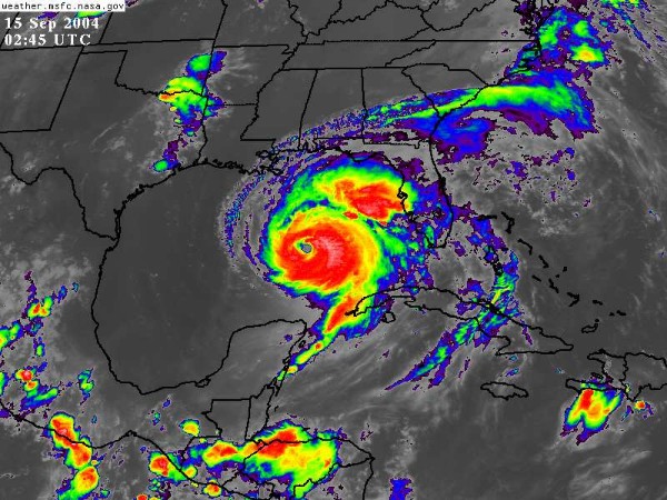
Updated regularly: Satellite image of Hurricane Ivan
Graphic by Naval Atlantic Meteorology and Oceanography Center
...Large and extremely dangerous hurricane Ivan headed for the northern gulf coast...
A hurricane warning is in effect from grand isle Louisiana to Apalachicola Florida...Including the greater New Orleans area and Lake Pontchartrain. A hurricane warning means that hurricane conditions are expected within the warning area...Generally within the next 24 hours. Preparations to protect life and property should be rushed to completion throughout the entire warning area.
A hurricane watch remains in effect from Morgan City Louisiana to west of grand isle.
A tropical storm warning is in effect from Intracoastal city Louisiana to west of grand isle...And from east of Apalachicola to Yankeetown Florida. A tropical storm warning means that tropical storm conditions are expected within the warning area within the next 24 hours.
At 10 pm CDT...0300z...The tropical storm watch for the Florida keys from the seven mile bridge westward...Including the dry Tortugas...Has been discontinued.
At 10 pm CDT...0300z...The eye of hurricane Ivan was located near latitude 25.1 north... Longitude 87.2 west or about 295 miles south-southeast of the mouth of the Mississippi river.
Ivan is moving toward the north-northwest near 12 mph and a gradual turn to the north is expected on Wednesday.
Maximum sustained winds are near 140 mph...With higher gusts. Ivan remains an extremely dangerous category four hurricane on the Saffir-Simpson hurricane scale. Fluctuations in intensity are common in major hurricanes and are possible over the next 24 hours. Ivan is expected to make landfall as a major hurricane...At least category three.
Ivan is a large hurricane. Hurricane force winds extend outward up to 105 miles from the center...And tropical storm force winds extend outward up to 260 miles. Hurricane force winds are expected to spread inland up to about 150 miles near the path of Ivan.
A NOAA hurricane hunter aircraft measured a minimum central pressure of 932 mb...27.52 inches.
Coastal storm surge flooding of 10 to 16 feet above normal tide levels...Along with large and dangerous battering waves...Can be expected near and to the east of where the center makes landfall. Lesser...But still significant surge values will be experienced where onshore flow occurs west of the center. Water levels are already running up to 1 foot above normal along the north gulf coast...And will be increasing overnight.
Dangerous surf conditions...Including rip currents...Are likely elsewhere along the Florida gulf coast.
Rainfall accumulations of 10 to 15 inches...With isolated higher amounts...Can be expected in association with Ivan.
Repeating the 10 pm CDT position...25.1 n... 87.2 w. Movement toward...North-northwest near 12 mph. Maximum sustained winds...140 mph. Minimum central pressure... 932 mb.
For storm information specific to your area...Please monitor products issued by your local weather office.
An intermediate advisory will be issued by the national hurricane center at 1 am CDT followed by the next complete advisory at 4 am CDT.
Updated regularly: Satellite image of Hurricane Ivan


| NOTE: In accordance with Title 17 U.S.C. section 107 this material is distributed without profit or payment to those
who have expressed a prior interest in receiving this information for non-profit research and educational purposes only.
For more information go to: http://www.law.cornell.edu/uscode/17/107.shtml. If you wish to use copyrighted material
from this site for purposes of your own that go beyond fair use you must obtain permission from the copyright owner. |