
|
|

Hurricane Ivan Advisory
National Hurricane Center Miami Fl
5 PM AST THU SEP 09 2004
Updated regularly: Satellite image of Hurricane Ivan
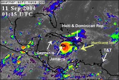

...Hurricane Ivan heading for Jamaica and the Cayman islands...
A hurricane warning is in effect for Jamaica.
At 5 pm...2100z...The government of the Cayman Islands has issued a hurricane warning for the Cayman islands.
A hurricane watch and a tropical storm warning remain in effect for the entire southwest peninsula of Haiti from the border of the Dominican Republic westward...Including Port au Prince.
A hurricane watch and a tropical storm warning is in effect for the Dominican Republic from Barahona to Perdenales. A tropical storm watch remains in effect for the southwestern coast of the Dominican Republic from Palenque westward to Barahona.
A hurricane watch is in effect for central and eastern Cuba from Matanzas eastward.
Interests in central and western Caribbean Sea should closely monitor the progress of dangerous hurricane Ivan.
At 5 pm ast...2100z...The center of hurricane Ivan was located by a reconnaissance plane near latitude 15.0 north...Longitude 72.5 west or about 350 miles... 565 km...Southeast of Kingston Jamaica.
Ivan is moving toward the west-northwest near 15 mph ...24 km/hr...And this motion is expected to continue during the next 24 hours. On this track the hurricane will be nearing Jamaica on Friday.
Although maximum sustained winds have decreased to near 150 mph...240 km/hr...With higher gusts....Ivan is a dangerous category four hurricane on the Saffir-Simpson hurricane scale. Some fluctuations in intensity are likely during the next 24 hours.
Hurricane force winds extend outward up to 35 miles... 55 km...From the center...And tropical storm force winds extend outward up to 175 miles...280 km. Latest minimum central pressure reported by an air force reconnaissance plane was 921 mb...27.20 inches.
Storm surge flooding of 3 to 5 feet above normal tide levels… Along with large and dangerous battering waves...Can be expected near the center of Ivan in the hurricane warning area.
Rainfall amounts of 5 to 7 inches...Possibly causing life-threatening flash floods and mud slides...Can be expected along the path of Ivan.
Repeating the 5 pm AST position...15.0 n...72.5 w. Movement toward...West-northwest near 15 mph. Maximum sustained winds...150 mph. Minimum central pressure...921mb.
For storm information specific to your area...Please monitor products issued by your local weather office.
An intermediate advisory will be issued by the national hurricane center at 8 pm AST followed by the next complete advisory at 11 pm AST.
Latest NCEP/Tropical Prediction Center (TPC) Forecast Positions

| NOTE: In accordance with Title 17 U.S.C. section 107 this material is distributed without profit or payment to those
who have expressed a prior interest in receiving this information for non-profit research and educational purposes only.
For more information go to: http://www.law.cornell.edu/uscode/17/107.shtml. If you wish to use copyrighted material
from this site for purposes of your own that go beyond fair use you must obtain permission from the copyright owner. |