|
Barbados Opposes T&T's Archipelagic Status
Posted: Wednesday, April 7, 2004
by Stephen Kangal, Caroni

According to Foreign Minister Gift (Newsday Feb.21, p.11) Barbados has refused to recognise T&T's archipelagic status in the 5 rounds of bilateral negotiations. This status is legitimately derived from and justified by the sovereign state of T&T consisting of 23 islands. They are so closely interrelated that they constitute an "intrinsic geographical and political unit" similar to archipelagic states such as Indonesia, Fiji and the Philippines.
This expanded maritime jurisdiction was promulgated by Act No.24 of 1986. It is in accordance with Part IV of the 1982 UN Convention on the Law of the Sea (UNCLOS) in that it meets the requisite land/archipelagic waters ratio ranging from 1:1 to 1:9.
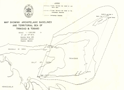
When furthermore T&T's archipelagic baselines were declared and their co-ordinates cited and published in Legal Notice No.206 of 17 October 1988 and subsequently registered with the UN, Barbados again failed to protest or reserve its position. Barbados also failed to lodge the relevant legal protest against the 1990 TT/Venezuela Treaty and is now illegally holding out against the binding nature or opposability of both instruments. Accordingly it is refusing in the negotiations to recognise the competence of T&T to use the long straight baseline extending from East Rock to Little Tobago to measure its EEZ/ CS. Th is and other lines are shown on the illustrative chart.
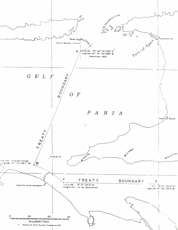
This is not the first time that T&T has extended sea boundaries beyond the low water mark. On 26 February 1942 the British Colonial Administration concluded the Gulf Of Paria Treaty with Venezuela to claim the submarine areas (continental shelf (CS) located beyond the then 3-mile territorial sea (TS)) and then issued the Submarine ľAreas- of the Gulf of Paria (Annexation Order) 1942 to include this marine area within the territory of T&T (please see Attached Chart showing the old 1942 Boundary Line). This treaty in fact and in law has been replaced by the boundary connecting points 8 to 13 of the now in force 1990 boundary with Venezuela.
T&T, by fulfilling all the requisite geographical and legal criteria/requirements to qualify for assuming archipelagic status, has expanded its maritime jurisdiction and control to our additional benefit. T&T satisfies the requisite water to land ratio of 1 to 1 or 9 to 1 as prescribed in Article 47(1), Part IV of UNCLOS to qualify to be recognised as an archipelagic state.
Consultant Hydrographer from the Canadian Hydrographic Service, Mr. E.J. Cooper brought in by the late patriot, Lennox Ballah assisted T&T in 1980 to undertake the studies/calculations before arriving at the decision to declare its archipelagic status. The archipelagic water to land ratio of the T&T 23 islands archipelago that is enclosed by the archipelagic straight baselines is approximately 1.4 to 1 i.e. an archipelagic water area of 7,158 sq. kilometers and a land area of 5,117 kilometers.
The effect of using the straight archipelagic baselines as shown on the chart has resulted in an increase in the areal extent and seaward extension of T&T's maritime zones (TS, EEZ and CS). The chart shows the considerable change in the seaward extension of the 12- mile TS when it is measured from the said straight baselines compared to the more landward location when measured from the low water in 1969. Additionally, whereas there were areas of high seas located in the Gulf of Paria (pre-1986) east of the 1942 AB boundary, now all marine areas located east of points 8 to 9 (1990 Treaty) constitute part of our 12-mile territorial sea. In fact there are no areas of high seas on either side of points 8 to 9 with the coming into force of the archipelagic baselines and the declaration of a 200-mile Exclusive Economic Zone (EEZ) by both Venezuela and T&T.
In relation to the East Coast, the archipelagic baseline extending from East Rock (Point 1) to Little Tobago (Point 11), which incidentally has been recognised by Venezuela, Barbados, Guyana and Grenada had the advantageous effect of deflecting the agreed TT/ Venezuela 1990 equidistance boundary further southwards into the South East Atlantic thus increasing considerably the seaward extent of T& T's EEZ. Additionally T&T proposes to use this baseline not only to measure its boundary with Barbados but also to quantify the relative lengths of the admissible and relevant coastal facades of both Barbados and T&T in their adjacent positions. This is critical when the relevant and important principle of proportionality (relationship/ratio between the lengths of the relevant coastal fašades and marine areas allocated) becomes operative or admissible in the delimitation/negotiation/ adjudication processes.
It is to be noted that the archipelagic status of T&T did not produce any additional maritime benefit for us vis-Ó-vis Venezuela in the Gulf of Paria, the Columbus Channel and the Caribbean Sea but will favour T&T in maritime boundaries to be concluded with Grenada and St.Vincent and the Grenadines when such negotiations begin.
By declaring itself an archipelagic state, T&T assimilated the Galleon's Passage (lying between Trinidad and the sister isle) under its archipelagic waters regime. However since this was a strait internationally and historically recognised for international navigation, T&T must now accord to ships of all nations the right of transit passage between the islands. The right of transit passage cannot be suspended but ships are required when exercising this right to refrain from posing any threat or using force the threaten the territorial integrity, sovereignty or political independence of T&T. T&T must also accord the right of transit passage within its archipelagic waters (waters enclosed by the straight baselines) that were formerly part of the TS of T&T that was measured from the low water mark in accordance with the Territorial Sea Act 1969.
Within its archipelagic waters T&T has an obligation to designate archipelagic sea-lanes passage and air routes for foreign ships and aircraft respectively. However, having not declared such sea lanes/air route ships and aircraft are entitled to use routes normally recognised for international navigation pending the designation of such sea-lanes and air routes by T&T.

 Send page by E-Mail Send page by E-Mail
|
|